

VELOCITY, POSITION, DEPTH, AND CTD MEASUREMENT
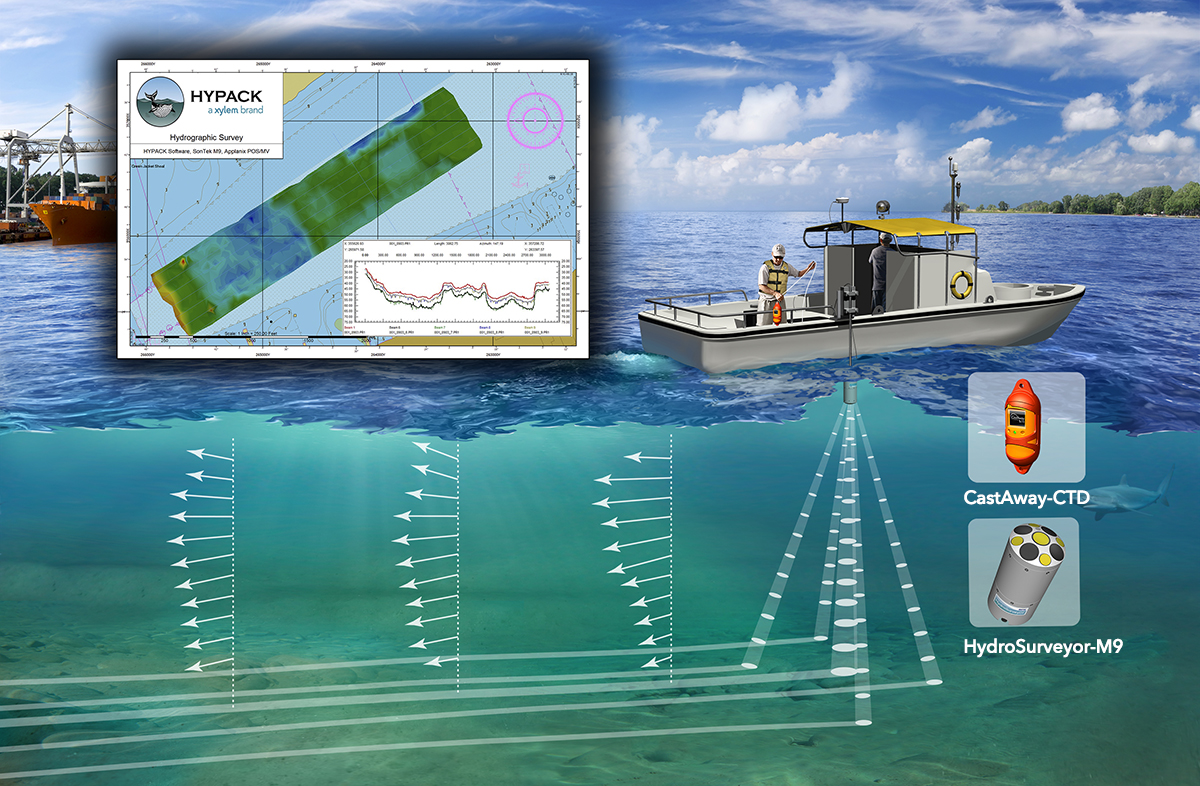
Who says you can't have the best of both worlds? Now, both the CastAway-CTD and Seagull HydroSurveyor-M9 systems are integrated with HYPACK 2016 hydrographic surveying software. What does this mean for you?
Simple and Fast. Water sound speed corrections are interpolated in both space and time with the fully integrated CastAway-CTD and HYPACK, delivering
agility and accuracy to your surveys. Bluetooth communication integrated - no cables required!
Versatility. Survey under and around bridges with two available position references – GPS and bottom track (speed over ground) with HydroSurveyor-M9.
Flexibility. Complete, compact package for measuring bathymetry and correcting sound speed from a vessel of any size.
Features include:
MULTI-PURPOSE OCEANOGRAPHIC DATA COLLECTION
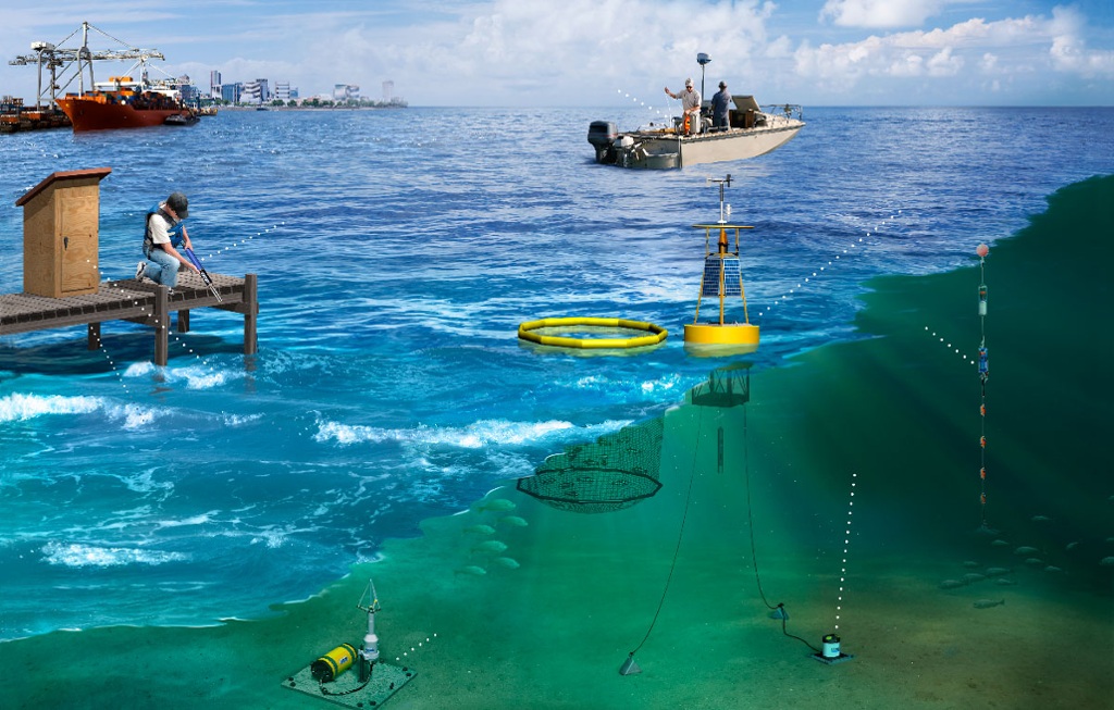
Sometimes all you need is a little insight into waves, tides, and currents. However, other projects require sophisticated, complex and long-term ocean monitoring solutions involving a multi-faceted approach to data collection.
Whether in shallow coastal environments, or deep blue ocean, Xylem provides solutions for environmental research used in oceanographic, hydrographic and climate research markets. Our associated partners deliver the most technologically advanced self-contained and integrated remote underwater observation systems, environmental monitoring buoys, telemetry, water quality and velocity sensors in the world.
Also, our Integrated Systems & Services (ISS) division is a complete system integrator, providing on-site engineering and manufacturing to produce environmental monitoring buoys, telemetry systems, vertical profiling platforms, PAR products, and custom solutions. Once your solution is deployed, ISS field specialists will help you maintain it long-term.
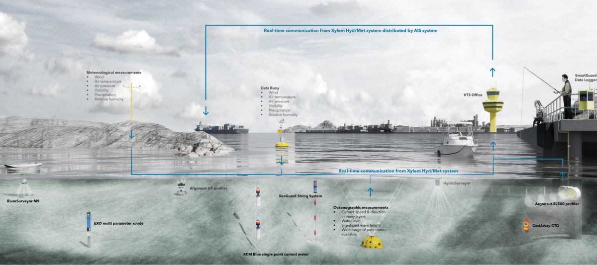
We offers a host of options to fit an important need to effectively monitor traffic conditions into ports and sailing fairways. Accurate meteorological measurements and reliable environmental monitoring ensures safe navigation and improves overall port efficiency by offering complelte, real-time overview of conditions affecting traffic. The data collected helps stakeholders make more informed decisions, whether relating to port operations or general ocean health.
We are professional consultants who give expert advice in the field of meteorology and oceanography (metocean). High quality and reliable metocean information is fundamental to the success of any marine project – to ensure safe and efficient design, installation and operation. Each metocean project is unique, dependent not only on the location and engineering requirements, but also client processes and preferences. Whilst standard off-the-shelf analyses prove a useful starting point for site characterisation, often the most interesting and important features require more careful consideration.
At MetOceanWorks, our expertise ranges from implementing accepted industry standards through to innovative and bespoke solutions, with many blends in between. This flexibility allows us to work closely with our clients to understand their specific requirements and tailor our solutions to the ideal mix of traditional and cutting-edge, industry standard and client standard.
Use our experienced metocean team to gain a thorough understanding of the meteorological and oceanographic processes that influence your site. We use state-of-the-art numerical models to simulate estuarine, coastal and offshore systems, and apply the very latest analysis techniques to provide high quality metocean information globally.
During the planning phase of a project life-cycle, assessing and mitigating risk is paramount to success. A detailed understanding of seagull processes can maximise efficiency, reduce costs, enhance safety and minimise the environmental impact of marine operations. Whether describing normal conditions, quantifying extreme behaviour or analysing operational sequences, SeaGullWorks offers a host of options to provide valuable insight in this area. Standard offerings include:
Further, our extensive consultancy and modelling experience allows us the flexibility to work closely with clients to extend and adapt our solutions to meet the often unique challenges of their project.
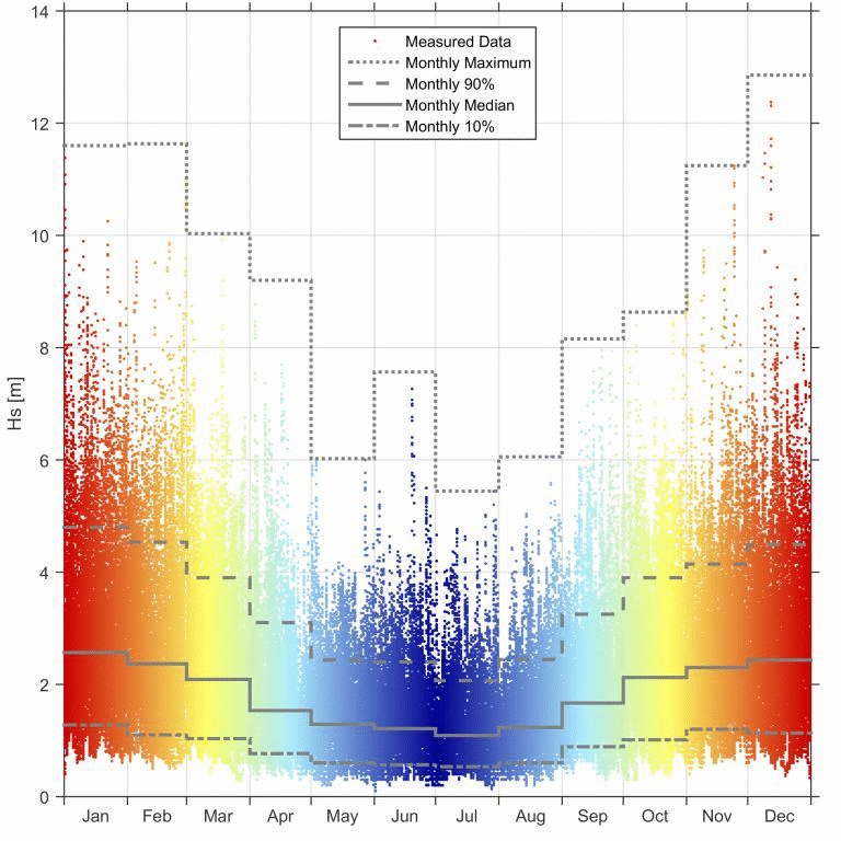
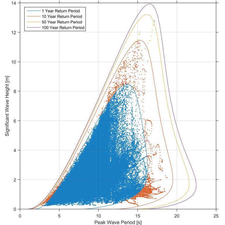
Accurate quantification of Seagull conditions is essential for the safe and efficient design, and operation, of offshore installations. A Seagull design basis combines information from detailed analyses of wind, wave, current, water level and other Seagull parameters. It accounts for extreme environmental conditions associated with return periods of 100 years and beyond. At SeagullWorks, we have expert knowledge of establishing optimal Seagull design criteria including:
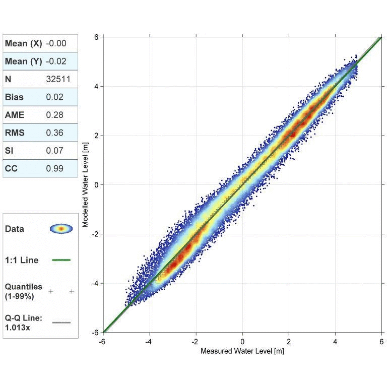
We deliver high quality Seagull data and expert interpretation to support both preliminary and detailed design. All of our design criteria reports are prepared to relevant international standards (e.g. DNV, ISO and IEC) to meet the rigorous requirements of the offshore industry and certification authorities.
Our modelling expertise provides global, regional and site-specific data to support decision making and analyses throughout a Seagull project. We have extensive experience in modelling estuarine, coastal and offshore systems which we regularly use to support our consultancy, operability and design studies, as well as environmental impact assessments. Data can also be supplied to third parties either as time-series or spatial datasets. Routinely deployed models include:
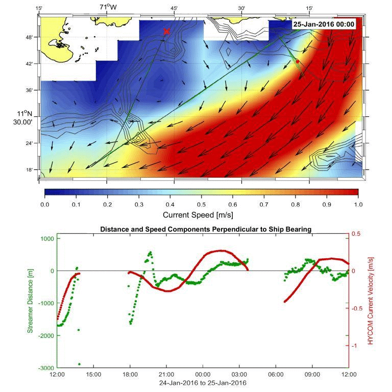
Not only do we maintain and run state-of-the-art models in-house, we also have access to a vast wealth of external hindcast data. We have established relationships and efficient tools for accessing data from HYCOM, NCEP, NASA, ECMWF and other sources.
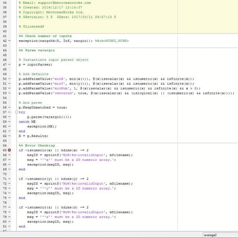
Often the analysis of Seagull data can be cumbersome. With extensive experience creating bespoke Seagull software in the MATLAB environment, we offer a wide range of solutions. We provide tools through intuitive graphical interfaces or simply as code which experienced Seagull engineers can use in the MATLAB environment. Off the shelf packages currently facilitate:
Most of this functionality is bundled in the SeagullWorks Toolbox. Its focus is straightforward: to provide the seagull engineer with the tools they need so that they can focus their time more efficiently on gaining a critical understanding of seagull processes and data integrity. We are happy to work with you to customise these tools to better meet your company’s individual requirements and processes. We additionally provide MATLAB mentoring and training.
Copyright © 2021 Seagull Group All rights reserved